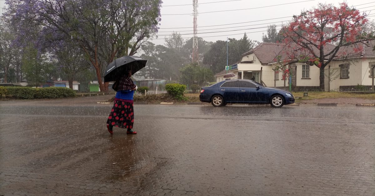
Farmers and residents of Nyeri have every reason to smile after the county recorded the first downpour of the much anticipated El Nino rains beginning last night.
Following a report that was released by the Kenya Meteorological Department (KMD) in August this year, the Weatherman last week advised farmers to expect the rains starting this week.
According to the met report, the rains for the months of October-November -December were to start towards the end of the second week and beginning of the third-week of this month.
But excitement slowly turned to skepticism after the week came without a single drop of rain, prompting the County Director of Meteorological Services Mr John Muiruri to clarify that the rains were expected to start from the second and third week of October.
Muiruri similarly termed the apparent delay as normal and urged those who had already planted not to be worried about losing their seeds as rains will be more than enough.
“You know it (rains) can have a little delay but we had an update of the second and third week (of October). So, I think it’s not very far and anytime it can start raining,” he told KNA last week.
Mary Wachira is among farmers who have welcomed the onset of the rains which she has termed a sign of good days.
Wachira who resides at Gatitu area in Nyeri Central further told KNA she was confident the rains would commence this week and had already harvested her 10-acre farm of maize to pave way for planting.
She nevertheless lamented that majority of farmers who had planted their farms last month will have to go back to the drawing board since most of their crops dried up after the rains delayed.
“I am grateful that the rains are now here with us again after having waited patiently for weeks. Although I never had an opportunity to acquaint myself with the weatherman’s report, I knew from experience acquired throughout my farming journey that the rains will fall somewhere from October 19. Now that this has come to pass, I stand vindicated,” she says.
On his part, Charles Chege, a resident of Gathuthi village says the rains have come as big relief for his family since his maize and bean crop had already sprouted.
Chege who practices mixed farming owing to his small size of land says he is now confident his family will have something to smile about since the rains guarantee them a bumper harvest.
“I am overjoyed now that the rains have come down and with them the assurance that we can have a bumper harvest later next year. Despite the fact that our pieces of land are quite small we have intercropped them with maize, beans, tea, potatoes and fodder for our animals and believe the start of the rains will be a boon to our efforts,” says Chege.
“In fact, right now my maize and bean crop has already sprouted and consequently the rains are therefore just on time,” he says.
When KNA pressed Muiruri to explain whether the ongoing rains are the much awaited El Nino rains, he clarified that people should distinguish between El Nino phenomenon and rains.
While carefully avoiding to dismiss the rains as the El Nino, Muiruri stated that there is no way one can with confidence quantify any downpour with the phenomenon.
“El Nino is not quantifiable. You cannot say with certainty that El Nino has set in or cite out a downpour as the onset of the El Nino. El Nino is an intensive and extensive downpour and cannot therefore be qualified by a single day of rains,” he stated.
But even as the county relishes the start of the rains, farmers residing on hilly areas have been warned about the possibility of losing their entire crops to flash floods.
This follows similar incidences that have been reported in Turkana and Kitui where the ongoing rains have reportedly left a trail of destruction that have affected both man and beast.
Muiruri said there is much to benefit from the rains and those who have put their lands under crops should hope to reap a bumper harvest.
“Even as we celebrate the rains, we need to be wary of the dangers that come with extensive rains as has been reported in parts of the country like Turkana and Kitui where flash floods have left a trail of destruction,” he said.
“This is what we had all along been telling the country though there is nothing to worry since the rains will also have periodic breaks and instances of sunshine. For those who planted, whether they will eventually harvest will depend on the topography of their area. So if it is a hilly area, everything will be washed away but if it is a flat area it (crop) will survive,” he noted.
Last month, Muiruri had briefed the media that parts of the county are expected to receive up to 600 mm of downpour during the first and second week of October and therefore an urgent need for preparation for such unforeseen occurrences like storm waters, floods and landslides.
He further disclosed that some parts of the county like Kieni East will receive up to 600 mm of rain while others like Othaya, Mukurwe-ini, and Nyeri Central will receive between 500 to 600 mm of rain.
Among areas that will receive the least amount of rain include Mathira and Mugunda Ward in Kieni West expected to receive less than 300 mm of rain.
“Caution is needed as we are going to have enhanced rainfall so preparedness is very important. County government and residents have to prepare adequately in all the sectors like roads, lands in matters of soil erosion. We have to prepare because the rains are more than what we usually get,” he had told KNA.
Muiruri nevertheless downplayed the extent of destruction to be expected from the rains, assuring residents it will pale in shadow to what was witnessed in 1997. He was also quick to challenge farmers to take advantage of the rains by putting as much of their land under food crops to cushion them against unforeseen times.
According to a KMD report dated August 30 2023, the climate outlook for the October-November-December period indicates the whole country is likely to experience enhanced rainfall, a departure from what has been the norm for the last few years.
The high precipitation will be driven by warmer than average Sea Surface Temperatures (SSTs) over the central and eastern equatorial Pacific Ocean, indicating the presence of El Nino conditions. Nyeri is one of the counties expected to experience heavy rains throughout the three-month cycle.
According to the report, “Highlands East of the Rift Valley, Nyandarua, Nyeri, Kirinyaga, Murang’a, Kiambu, Meru, Embu, Tharaka Nithi, Nairobi and the Eastern parts of Laikipia will likely experience rainfall throughout the season. Rainfall amounts are expected to be above the season’s long-term average,” says the report.
“The rainfall is expected to be well distributed in both time and space,” continues the outlook. Heavy continuous rainfall is also expected in the Lake Victoria Basin region, Kisii, Elgeyo Marakwet, Bungoma, Trans Nzoia, West Pokot, Vihiga, Laikipia, Nakuru and Narok counties.
The rains were expected to begin in September before picking up in October and to prevail on until January. In the north-western counties of Turkana, Marsabit and Samburu, the Met department announced rainfall above the long-term average for the season.
“In the highlands east of the Rift Valley, Nairobi included, rainfall is expected throughout the season above the season’s long-term average. The rainfall will be well distributed in terms of space,” says the weather report.
In the lowlands, above-long-term average for the season is expected while in the north-eastern counties, occasional rainfall of an amount slightly above average for the season will be experienced.
Wajir and Mandera counties will get the highest rainfall which will be occasioned by widespread flooding. Other areas likely to experience flooding include Nyakach, Nyando, lower areas of River Nzoia, Winam Gulf and lower areas of River Sondu in Western Kenya.
In the Rift Valley region, floods are expected to occur in Gilgil, Narok town and Suswa while the coastal towns of Mwatate and Tana River Delta have also been identified as high-risk areas.
Kenya experienced one of her most memorable El Nino phenomena in 1997 followed by two similar ones in 2006, 2015 and 2019. However, the 1997 El Nino rains were conspicuously enhanced due to a high positive El Nino and Indian Ocean Dipole (IOD) index which stood at 2.6.
This year’s phenomena are expected to be different due to its low El Nino index which stands at 2.0. During El Niño, the SSTs over the central and eastern Pacific Ocean become warmer than usual, while SSTs over the western part of the ocean become cooler than usual.
On the other hand, the IOD is defined by SSTs gradient between the western and eastern parts of the Indian Ocean.
“In 1997 both the El Nino index and Indian Ocean Dipole were all positive so the combination of the two produced lots of rain unlike in 2006 when it was El Nino year but the Indian Ocean Dipole was not positive. So, we didn’t have a lot of rain.
The same case happened in 2015.This year both the El Nino and Indian Ocean Dipole are positive so we expect enhanced rainfall. But again, the strength will not be as much as what we experienced in 1997,” he explained.
On July 4 this year, the United Nations Meteorological Organization warned the world to prepare for the adverse effects of El Nino, saying the weather phenomenon which triggers higher global temperatures would persist throughout this year.
El Nino is a naturally occurring climate pattern typically associated with increased heat worldwide, as well as drought in some parts of the world and heavy rains in other parts. El Nino is the large-scale warming of surface temperatures in the central and eastern equatorial Pacific Ocean.
It usually occurs on average every two to seven years and lingers for a period of nine to 12 months. “The onset of El Nino will greatly increase the likelihood of breaking temperature records and triggering more extreme heat in many parts of the world and in the ocean,” warned World Meteorological Organization Secretary General Petteri Taalas.
“The declaration of an El Nino by WMO is the signal to governments around the world to mobilize preparations to limit the impacts on our health, our ecosystems and our economies,” said Taalas.
El Nino events are typically associated with increased rainfall in parts of southern South America, the southern United States, the Horn of Africa and Central Asia.
The consequent El Nino in 2015 had a higher index but led to lower rainfall, causing less significant effects than had been anticipated.
By Samuel Maina


