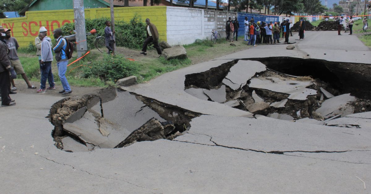
The Nakuru County Government has declared a Moratorium on building approvals for structures within sections of the Central Business District and its suburbs after experts confirmed that the areas were geologically unstable and were experiencing subtle volcanic faulting.
Seismologists and geologists from Kenya Electricity Generating Company (KenGen) and Geothermal Development Company (GDC) have also called on the County administration to put in place systems to monitor seismic activities as Nakuru was prone to major and minor earthquakes.
The report on the state of geological stability of the devolved unit presented to Governor Lee Kinyanjui by experts from GDC and KenGen had established that large sections of Nakuru has cracks and fissures that posed danger to buildings and other infrastructure and that soil in the region and its environs was unconsolidated as a result of past eruptions from the Menengai Crater.
Speaking in his office, the County boss announced that the geologists would continue monitoring the situation for the next 60 days and that he had suspended approval of infrastructure development plans for parts of Tim sales, Total areas within the CBD and Shabab and Koinange Estates in Nakuru West Sub-County.
The County administration has now been forced back to the drawing board following occurrences of huge ground fissures and cracks that have been reported in various parts of the devolved unit at alarming frequencies.
The devolved unit was spurred into action after fault line cut across roads in Nakuru West Sub-County following heavy rains that pounded the region sparking fears among residents of Koinange, Shabab and Kaptembwa Estates.
“More geological and seismic surveys will be conducted in the entire Central Business District. After engineers and experts from KenGen and GDC map out the extent of the fault line, the affected areas will be beaconed to ensure that authorities make informed decisions before approvals for property developments are made in certain areas,” said governor Kinyanjui.
“Legally, there is a limit on the height of buildings that should be constructed in Nakuru. Construction of buildings that have more than three storeys must have a report from a geologist,” he said.
Governor Kinyanjui said his administration would restructure its engineering department and hire seismologists and geologists who would ensure infrastructure complied with required standards that can withstand seismic activities.
“We will also bring on board the environment departments as experts have confirmed increasing storm drainage water that seeps into the ground and increases the risks significantly is as a result of destruction of forest cover in parts of the county,” he said.
“After engineers and experts from KenGen and GDC map out the extent of the fault line, the affected areas will be beaconed to ensure that authorities make informed decisions before approvals for property developments are made in certain areas,” stated the governor.
In their findings the geologists cautioned that some storeyed buildings in Nakuru were catastrophe in the making due to the weak soil structure.
Though the Building and Construction Standards and Codes (BCSC) developed by the defunct Municipal Council of Nakuru insisted on development of low-storey buildings- less than four floors- this is currently not the case. Dozens of new buildings with as many as 12 storeys were now fighting for space in the County’s skies.
Governor Kinyanjui called on investors who had developed commercial and residential properties on the path of the fault line ‘to brace themselves’ for tougher measures as his administration moves to implement directives that will be rolled out to eliminate risks associated with structural weaknesses in their buildings.
“We will ensure that people move away from all structures that are on the path of the fault line after the study is carried out. This is a very serious matter that will impact negatively on structural strength of most buildings,” Kinyanjui said.
“The County administration will make appropriate decisions once a final report by the experts is ready,” said the County boss.
The report was compiled by Seismologists from KenGen, Cyrus Karingiti and Kizito Opondo and Eng. Paul Ngugi, a geologist from GDC.
The experts have cautioned that before any infrastructure and housing projects are carried out in the County, geothermal mapping should be carried out as the region is highly vulnerable to subsidence (sinking down of land from natural earth movement), landslides, earthquakes and related disasters.
Eng. Karingiti said whereas some parts of Rift Valley had remained tectonically inactive in the recent past, there could be movements deep within the Earth’s crust that have resulted in zones of weakness extending all the way to the surface.
He said the risks continued rising as a lot of water has entered the fissures causing underground erosion even in places that have not caved in.
Opondo revealed that Nakuru lay on the path of a major fault line that runs from North to South of the devolved unit and that infrastructure built along the weak zone were at high risk especially during the wet season.
Eng. Ngugi stated that an assessment by his team had established that the fault line could be just one of the tens, perhaps hundreds, of other weak spots on the Great Rift Valley, which runs through the continent from the Horn of Africa to Mozambique.
“During heavy rains and flush floods, the fissures, due to unconsolidated deposits accompanied by slumping and flushing of material deep down, produce holes and funnel shaped depressions, which cannot hold heavy weights,” he said.
Last year, a similar occurrence in Naivasha Sub-County cut the busy Mai Mahiu-Narok road, an area known to have inherent geological weaknesses. Eng. Ngugi said that the Rift Valley region was still prone to volcanicity.
In February this year, fear struck residents of Solai as the newly constructed dam locally known as Nyaru Dam, in Solai Subukia Sub County developed a huge fault.
The fault lines were running below the Nyaru water pan, and some of the neighbouring homesteads due to deep cracks and soil slides, resulting in the loss of all the water in the dam and cracks in some houses. It is suspected the dam lies on the volcanic line flowing from the nearby Menengai Crater.
Twelve kilometers away in Nakuru East Sub-County, a section of residents from White house Estate in the outskirts of Nakuru town are living in fear after ground fissures developed in the area.
The residents, whose estate is at the foot of the Menengai Crater said though the fissures have not extended for a long distance, they could not be ignored as there were signs of them widening with time.
Geologist hold the opinion that in the Eastern Africa region, Somalia and half of Ethiopia, Kenya and Tanzania will be cut off from the rest of Africa to create a new continent in about 50 million years- known as the Somali Plate.
Forces of the Earth are the strongest at the base of the valley, yet it is also here that geological processes are most active.
The town is located on the floor of the Great Rift Valley, in a narrow gap between Menengai Crater to the North and Lake Nakuru to the South. Hence, the town can only expand in a linear pattern to the West and East.
The situation is further compounded by the presence of unstable geology and poor soils which results in frequent land subsidence.
A report compiled by researchers from the Department of Geology, University of Nairobi indicated that most parts of Nakuru particularly the West and Southwest, often experienced ground failure –– shaking that affects the stability of the ground –– during earthquakes.
Bangladesh, North of Nakuru GK Prison, Githima, Ngata, Rhonda estate, and Baruti shopping centres were identified as areas having the weakest surface points.
“These areas have very poor surface runoff because of fissures running across them from Menengai Crater that erupted thousands of years ago,” stated part of the report.
By Anne Mwale/Jane Ndiritu


