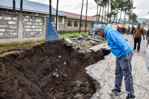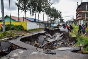

A fault line that initially developed in parts of Nakuru West Sub-County recently continues to wreak havoc after spreading into a public primary school destroying feeder roads and structures at the institution.
Governor Lee Kinyanjui said geologists from Kenya Electricity Generating Company (Kengen) and seismologists from Geothermal Development Company (GDC) were assessing the extent of the fault line at Koinange Primary School after its entire perimeter wall curved into a newly developed huge fissure.
The County boss who toured the institution in company of area Member of Parliament, Samuel Arama and Shabab Ward Member of County Assembly, Kamau Githengi said the experts from the two state corporations will continue monitoring faulting and volcanic activities at the school before learning institutions re-open.
“We must actively preempt possible dangers to avoid disasters at the school. Once the report from experts on the status of geological stability of the ground the school stands on is ready we will make appropriate decisions that will ensure safety of our children and teachers”.
The school established in 1950’s is staffed by the Ministry of Education and run by the County government. It hosts over 1,500 pupils hailing from the neighbouring populous settlements of Kaptembwa, Shabab, Ronda, Kenlands, Langa Langa and Mwariki Estates. It has over 60 teachers and 12 non-teaching staff members.
Last month, the fault line first cut across roads in the sub-county following heavy rains that pounded the region sparking fears among residents of Koinange, Shabab and Kaptembwa Estates.
Kinyanjui has since declared a moratorium on building approvals for structures within sections of the Central Business District and its suburbs after a joint GDC and Kengen geophysics report handed over to the county government confirmed that the most parts of the devolved unit were geologically unstable and were experiencing subtle volcanic faulting.
As Kinyanjui had suspended approval of infrastructure development plans for parts of Timsales, Total roundabout and Pyrethrum Estates within the CBD and Shabab and Koinange Estates in Nakuru West Sub-County scores of landlords in the affected parts are counting losses after tenants moved out of their premises fearing for their lives.
“We sincerely thank residents for voluntarily vacating houses near the collapsed road. Anyone seeking approval of a new building in Nakuru will have to provide a Geo-technical report which has a detailed structure of the earth’s profile.
Our engineering department is working on standards to ensure any building coming up has high safety specifications. As a county we will not approve any plan until we have a detailed report that will allow us assess the areas,” said the governor.
The geophysics study was aimed at investigating the nature of soil strata around collapsed zones, determining the depth and thickness of various soil strata, locating possible weak zones and determining cause and possible remedial measures.
The report indicated that general alignment of the weak zones showed presence of a major North-South fault. The weak zones as per the report findings enlarge southwards posing high risk to infrastructure around the area.
“Infrastructure built around weak zones is at high risk especially during wet seasons/lubrication of faults and enlargement of subsurface flow channels.
Whereas the rift has remained tectonically inactive in the recent past, there could be movements deep within the Earth’s crust that have resulted in zones of weakness extending all the way to the surface ,” read the report.
The report was compiled by Seismologists from KenGen, Cyrus Karingiti and Kizito Opondo and Eng. Paul Ngugi, a geologist from GDC.
The experts have cautioned that before any infrastructure and housing projects are carried out in the County, geothermal mapping should be carried out as the region is highly vulnerable to subsidence (sinking down of land from natural earth movement), landslides, earthquakes and related disasters.
Eng. Karingiti said whereas the some parts of Rift Valley had remained tectonically inactive in the recent past, there could be movements deep within the Earth’s crust that have resulted in zones of weakness extending all the way to the surface.
He said the risks continue rising as a lot of water has entered the fissures causing underground erosion even in places that have not caved in.
Opondo revealed that Nakuru lay on the path of a major fault line that runs from North to south of the devolved unit and that infrastructure built along the weak zone were at high risk especially during the wet season
Eng. Ngugi stated that an assessment by his team had established that the fault line could be just one of the tens, perhaps hundreds, of other weak spots on the Great Rift Valley, which runs through the continent from the Horn of Africa to Mozambique.
“During heavy rains and flush floods, the fissures, due to unconsolidated deposits accompanied by slumping and flushing of material deep down, produce holes and funnel shaped depressions, which cannot hold heavy weights,” he said
By Anne Mwale/Jane Ndiritu


